A Kobe University research group has shed light on how low-frequency tectonic tremors occur; these findings will contribute towards better predictions of future megathrust earthquakes.
In addition to the subducting Pacific plate, the Alaska subduction zone is also characterized by a subducting oceanic plateau called the Yakutat terrane. Low-frequency tectonic tremors, which are a type of slow earthquake, have only been detected in the subducted Yakutat terrane area. However, the mechanism by which these events occur is not well understood.
Researchers at Kobe University performed a 3D numerical thermomechanical simulation of thermal convection in the Alaska subduction zone with the aim of revealing the mechanism behind these low-frequency tremors. Based on the 3D thermal structure obtained from the simulation, and the indications of hydrous minerals contained in the slab, the researchers calculated the water content distribution and compared the results of these calculations in the area where the tremors occur.
The results revealed high levels of dehydration in the marine sediment layers and ocean crust in the earthquake region. The researchers believe that the reason the tremors only occur in the Yakutat terrane is because the marine sediment layers and ocean crust are thicker there, which means that the level of dehydration is higher than in the western adjacent Pacific plate (where tectonic tremors don’t occur).
The Kobe University research group consisted of 2nd year Master’s student IWAMOTO Kaya (Department of Planetology, Graduate School of Science), Academic Researcher SUENAGA Nobuaki and Professor YOSHIDA Shoichi (both of the Research Center for Urban Safety and Security).
These results were published in the British online scientific journal ‘Scientific Reports’ (Nature Publishing Group) on April 14, 2022.
Main points
- Elucidating the mechanism by which low-frequency tremors occur is important for understanding the plate subduction process. It is believed that this will also help illuminate how shallower megathrust earthquakes occur.
- In this study, the research group constructed a 3D thermomechanical model of the Alaska subduction zone and calculated the subducting plate’s maximum water content and level of dehydration.
- The dehydration levels from the subducting plate’s marine sediment layers and ocean crust were highest in the region where low-frequency tremors occur. Therefore, it is thought that the water expelled from the subducted plate contributes towards the occurrence of these tectonic tremors.
Research Background
An oceanic plateau called the Yakutat terrane is subducting in the Alaska subduction zone. Low-frequency tectonic tremors occur at this subducting plateau. The region where slow earthquakes (such as low-frequency tectonic tremors) occur is deeper and adjacent to the area where megathrust earthquakes occur, which suggests a connection between the two. Revealing the mechanism behind how low-frequency tectonic tremors occur is therefore important for understanding the occurrence of various earthquake events in subduction zones. This research group constructed a 3D thermomechanical model of the Alaska subduction zone so that they could investigate the temperature and level of dehydration in the areas near where low-frequency tremors occur.
Research Methodology
The researchers performed a 3D numerical thermomechanical simulation in accordance with the subduction of the Yakutat terrane and Pacific plate in the Alaska subduction zone. It is thought that as the Pacific plate subducts, it brings the hydrous minerals in the slab into the deep high temperature and high pressure regions, and these conditions cause a dehydration reaction where water is expelled from the hydrous minerals. Based on the 3D thermal structure obtained from the numerical simulation, the researchers determined dehydration levels of the hydrous minerals in the slab. From these results, it was understood that in the region where low- frequency tremors occur, a large amount of water is expelled due to the high temperature and high pressure conditions that cause the dehydration degradation reactions. It is thought that low frequency earthquakes don’t occur in the Pacific plate because it has thin layers and therefore experiences little dehydration. On the other hand, the Yakutat terrane’s ocean crust and marine sediment layers are comparatively thicker, meaning that it experiences high levels of dehydration. The researchers concluded that this is why low-frequency tectonic tremors only occur in the Yakutat terrane.
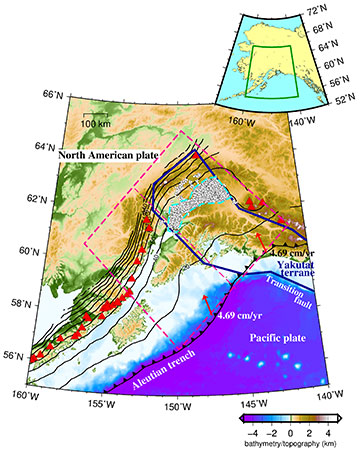
The thick blue solid line outlines the Yakutat terrane. The white circle indicates the epicentre of the low-frequency tectonic tremors, and the light blue dashed line shows the area where the tectonic tremors occurred, which is used in Figures 2 to 4. The area inside the pink dashed box is the model region used in this study, and the pink dashed line down the center of the box divides the model region into northeast and southwest areas, and represents the boundary between the subducted Yakutat terrane and the subducted Pacific plate in the model. The black lines indicate the isodepth contours of the upper surface of the subducted oceanic plate (with a contour interval of 20 km), red arrows show the plate motion velocity in the Aleutian Trench, and the red triangles indicate volcanoes.
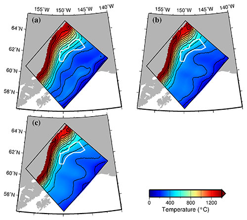
The temperature distribution is only plotted in the region where the depth of the slab surface is shallower than the bottom of the model (200 km), with a contour interval of 100 °C. The white line indicates the area where low-frequency tectonic tremors occur, as shown in Figure 1. (a) The slab surface (0 km). (b) 6 km depth from the slab surface. (c) 10 km depth from the slab surface.
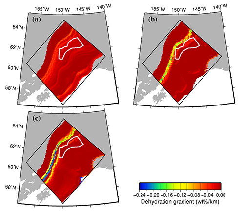
The dehydration gradient refers to the water content per unit length in the subduction direction of the plate. The dehydration gradient distribution is plotted only in the region where the depth of the slab surface is shallower than the bottom of the model (200 km) and where the temperature is higher than 200 °C (for which phase diagram data exists). The white line indicates the area where low- frequency tectonic tremors occur, as shown in Figure 1. (a) The slab surface (0 km). (b) 6 km depth from the slab surface. (c) 10 km depth from the slab surface.
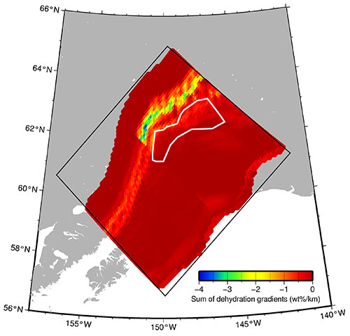
The black box indicates the modelled area. The vertical sum of the dehydration gradient is only plotted for the region where the depth of the slab surface is shallower than the bottom of the model (200 km) and where the temperature is higher than 200 °C (for which phase diagram data exists). The white line indicates the area where low-frequency tectonic tremors occur, as shown in Figure 1.
Further Research
In 1964, a megathrust earthquake occurred in Alaska. This is the biggest earthquake that has occurred in the Alaska subduction zone and the second most powerful earthquake recorded in world history. The low-frequency tectonic tremors that were the subject of this research occur close to the epicenter of the 1964 earthquake, at the downdip of the plate interface.
Next, the research group will continue to make thermomechanical models of various subduction zones to search for universal and regional characteristics of the causal mechanisms behind undersea megathrust earthquakes and slow earthquakes. This research will contribute towards improving understanding of how earthquakes occur and our ability to predict future megathrust earthquakes.
Glossary
1. Low-frequency tectonic tremors
A seismic event that is characterized by lower-frequency seismic waves than a regular earthquake.
2. Slow earthquake
A phenomenon where a fault slips at a slower speed than in a regular earthquake.
3. Oceanic plateau
A comparatively flat area of the seabed.
4. Slab
refers to the subducted plate.
5. Hydrous mineral
Minerals that contain OH groups in their crystal structure.
6. Dehydration degradation reaction
As the plate subducts, the resulting temperature and pressure causes phase transformations of hydrous minerals and they expel water.
Acknowledgements
Part of this study was supported by KAKENHI grants (16H06477, 21H05203) from the Japanese Ministry of Education, Culture, Sports, Science and Technology (MEXT).
Journal Information
Title
DOI
10.1038/s41598-022-10113-2
Authors
Kaya Iwamoto1, Nobuaki Suenaga2, Shoichi Yoshioka2,1
- Department of Planetology, Graduate School of Science, Kobe University
- Research Center for Urban Safety and Security, Kobe University
Journal
Scientific Reports (Nature Publishing Group)